|
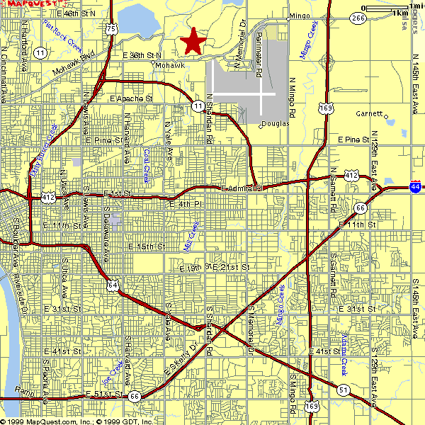
Coming from the West (I-44): After you exit the turnpike, take I-244 to I-244/US75. Stay with US75 when they split. After a big 'S' curve, you will PASS BY the highway 11/Gilcrease Expressway. Take the next exit, 36th St North. Go East until you pass Sheridan Road and the entrance to the park will be on your left. There will be a huge treeless hill to your right (airport runway).
From the East (I-44): After you exit the turnpike or 412 follow I-44 to I-244 (split to the right). Take I-244 past the US169 exchange to highway 11 (Airport). Take 11 past the Airport to Sheridan Road. Take Sheridan Road South (right) until it 'T's' at 36th Street North. Go East (right). Park Enterance is on left. Big treeless hill to your right (airport runway).
From the South (US75): As you approach Tulsa, US75 will pass over I-44. A mile or so later US75 and I-244 will merge, then split again. Stay with US75 when they split. After a big lazy 'S' curve, you will PASS BY the highway 11/Gilcrease Expressway. Take the next exit, 36th St North. Go East until you pass Sheridan Road and the entrance to the park will be on your left. There will be a huge treeless hill to your right (airport runway).
From the North (US75): As you approach Tulsa, you will see the street numbers of exits counting down (86th,56th,36th). Take the 36th Street North exit. Go East until you pass Sheridan Road and the entrance to the park will be on your left. There will be a huge treeless hill to your right (airport runway).
The other North (US169): You can make your own call on this one. The fastest way is to take 46th and go West. It will 'T' at a street that may be 36th, may be something else. None-the-less, this road hugs the southeast side of the park and turns into 36th. Take it until you see the Park entrance on the right. There will be a huge treeless hill on the left (airport runway). Otherwise, take US169 to I-244. Go west and take up the directions for the East approach. Look back here later, and the directions may be more defined.
From the Southeast (Muskogee Turnpike/Hwy 51): the Turnpike turns into the Broken Arrow Expressway. Take this to US169. Go North on US169 to I-244. Take I-244 West to Hwy 11 (airport). Take 11 past the Airport to Sheridan Road. Take Sheridan Road South (right) until it 'T's' at 36th Street North. Go East (right). Park Enterance is on left. Big treeless hill to your right (airport runway).
|
|
|